A River Wild
October 14, 2015
Amanda Nagy

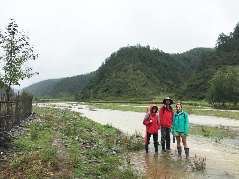
From left, Wang Xiuli, a PhD student at Sichuan University, stands with second-year Philip Swanson and fourth-year Megan Curiel in the river valley of Yangjuan, a village in southern Sichuan province. This picture was taken one day before the biggest flood to hit the valley in 60 years.
Photo credit: Amanda Schmidt
Assistant Professor of Geology Amanda Schmidt studies the ways people alter the landscape they live in. This research has taken her to China’s Sichuan province, in a remote valley populated by one of the country’s ethnic minorities, to help residents manage river flooding and erosion that was once thought to be a consequence of Communist deforestation policies.
As a geomorphologist, Schmidt is interested in events that shape the evolution of the landscape over a long period of time, up to a million years. Her involvement in this area of western China started about 10 years ago, when she was a graduate student in an interdisciplinary program at the University of Washington. An anthropology professor who works with indigenous communities in China needed geomorphologists to help corroborate oral histories told by the Yi people in Yangjuan and Pianshui, villages in southern Sichuan province.
Residents of the villages have complained that their landscape changed drastically after they followed modern Communist-era policies to cut down trees and expand their agriculture. The river that runs through their village floods often and causes significant erosion on the hill slopes.
This past August, Schmidt and University of Washington senior lecturer Brian Collins ’79 brought two students, fourth-year Megan Curiel and second-year Philip Swanson, to conduct field work in the village to try to answer questions about what—or who—has caused the soil loss and erosion, and to get an approximate time period for when the transformation took place.
As part of an ongoing collaboration with Sichuan University, Schmidt has been collecting samples in the village since 2008, and the data tell a story of a tectonically active landscape that has been altered by human activity. “If you go near the village, there’s almost no soil on the hill slopes. You dig a soil pit and you’re measuring in millimeters, which is not something geologists usually do. If you walk 5 kilometers up the watershed into the mountains, you’ve got a meter and a half of soil. And in the valley bottom, you’ve got these pretty big piles of sediment and all this dirt stored where the tributaries enter the main valley. It’s unlikely that all of that is related to modern Communist-era erosion,” Schmidt says.
Collins, Schmidt, and her students are trying to quantify the timing of when the sediments started piling up in the valley. She says all of the previous data show that the sediments started coming in a couple thousand years ago, and the reasons are probably not related to people.
However, the current state of the river and the more recent accumulation of thick piles of sediment along the river in the valley bottom tell a different story. “The floodplain has all these fine sediments, and in this environment, the main way you get fine sediments is to have a lot of surface erosion, such as from slash and burn agriculture, which is what the local people practice traditionally,” Schmidt explains. “Going into this field season, the dates we had looked like the floodplain deposition was from when the local people moved into this area based on the oral histories. So, we have been putting together this story that you have some background rates of erosion. Then, 250 years ago, the local people come in and they start farming on these hill slopes, and they get a lot of erosion. The erosion increases, and the sediment piles up on the valley bottom.”
The focus of their field work is to get more detailed dates for sediment movement and erosion. To accomplish this, the group is analyzing charcoal samples with radiocarbon and radionuclide datings. In August, the team sampled outcrops of deposited sediment for charcoal and mapped both sides of the river channel.
On their third day there, they experienced the biggest flood to hit the village in 60 years. “The storm was huge. A lot of crops were lost, and one family said they lost 20 goats. I’d rather not go back during the rainy season—it’s really unpleasant to be doing work on dirt outcrops in the rain.”
Schmidt describes the river as wild and woolly with sandbars and few trees growing in the middle. Since the residents started planting trees on the sides of the river five to eight years ago, it has become somewhat more stabilized. “It looks like the river at the mouth of a glacier: lots of rocks, and not much vegetation.
“We think the reason the river is a mess right now is mostly caused by people. Herds of animals that graze by the river have kept trees from growing—that’s part of the problem. The residents originally wanted the geomorphologists to tell them what they could do to try to restore their valley bottom. We think it would take a lot of money.”
Schmidt says all the trees along the river have had some positive effects, and trees in the river would be even better. “When you have a big tree in the river with a big root ball, you’re going to slow the flow and deposit a bunch of dirt behind it. It creates a more stable bar.”
This semester, Schmidt has four students in her lab working on projects related to the Yangjuan and Pianshui samples, which include sieving samples from soil pits and running tests to detect levels of cesium and lead isotopes to determine soil erosion rates and times.
Although she’d like to see the trees and wood left in place to help restore the river, Schmidt says it wouldn’t be practical given the economic conditions in the village, especially because residents use the wood to cook their food over fires. “Taking a long view, maybe we don’t have to recommend anything. There are fewer animals, and people are migrating to the cities. As more people migrate, people rely less on farm income.”
You may also like…
Oberlin Launches Critical AI Studies Minor in Fall 2026
With a solid foundation in both science and the humanities, this minor ensures students to understand and be able to analyze the ethical, cultural, environmental, political, economic, technological, and labor effects of AI.
Research Roundup
Every day, Oberlin’s faculty and students produce scholarly work that uncovers new insights into how we understand the world, particularly in the areas of sustainability and the environment.
Three Things with Jillian Scudder
Oberlin’s astrophysicist-author shines a light on our dark universe.


